3D Mobile Mapping Rail
Digital twin for modern rail infrastructure
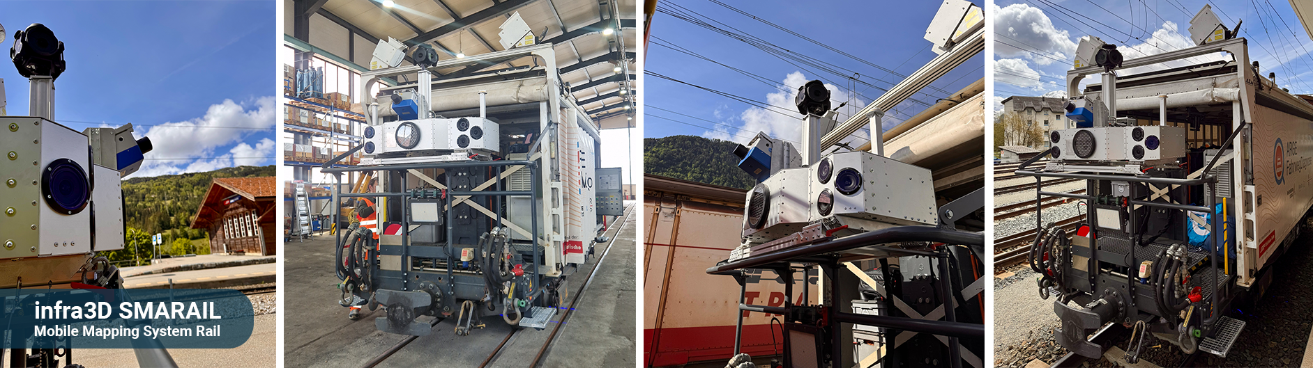
The new infra3D SMARAIL Mobile Mapping System (RealityCapture System) combines state-of-the-art camera, laser and navigation technologies in an integrated solution for the high-precision surveying of rail and road infrastructure. Equipped with panoramic cameras, colour and greyscale stereo cameras, a 360° laser scanner, a high-precision navigation solution and powerful stroboscopic IR lighting. It enables mobile, flexible and highly accurate data capture on a wide variety of carrier platforms – even under difficult environmental and lighting conditions.
How it works
The SMARAIL system comprises a panoramic camera system, a colour front-facing stereo camera system, a special greyscale front-facing stereo camera for the challenging lighting conditions in tunnels, a high-performance 360° profile laser scanner based on single-scanner technology, and INS/GNSS-based navigation sensors. The use of two GNSS antennas and alignment with the track survey points further optimises orientation accuracy. A central controller triggers the panorama and front cameras, synchronises all sensor data with the navigation information, and records the raw image data. Complemented by powerful stroboscopic IR lighting, the system enables reliable data acquisition even under difficult lighting and environmental conditions.
 – implemented as part of the ARGE Fahrwegdiagnose Consortium") infra3D SMARAIL in use for the Rhaetian Railway (RhB) – implemented as part of the ARGE Fahrwegdiagnose Consortium
infra3D SMARAIL in use for the Rhaetian Railway (RhB) – implemented as part of the ARGE Fahrwegdiagnose Consortium infra3D SMARAIL – Can be integrated into various support platforms thanks to its compact design
 infra3D SMARAIL - Mobile Mapping System Rail
") infra3D SMARAIL in use for Zurich Transport Services (VBZ)
infra3D SMARAIL in use for Zurich Transport Services (VBZ)") infra3D SMARAIL in use for Zurich Transport Services (VBZ)
infra3D SMARAIL in use for Zurich Transport Services (VBZ)") SMARIX in use in Zurich – City of Zurich and Zurich Public Transport (VBZ)
SMARIX in use in Zurich – City of Zurich and Zurich Public Transport (VBZ)
 – implemented as part of the ARGE Fahrwegdiagnose Consortium")


")
")
")
During the measurement run, navigation data is continuously recorded. Thanks to precise evaluation, supplemented by reference to the track survey points, the absolute position and orientation of our rail sensor system can be determined with high accuracy. The result is highly accurate, georeferenced 3D data of the railway infrastructure, which is provided in the new infra3D Rail Content version 3.0.
More about the new Content Version 3.0 Rail
Thanks to its compact design, the SMARAIL system can be flexibly integrated onto various carrier platforms. It thus offers an efficient, mobile and cost-effective solution for the acquisition, documentation and analysis of infrastructure and geodata in the rail sector.
The particular advantage: data collection takes place during ongoing rail operations via individually planned guided survey runs or by attaching the system to the rear of scheduled freight train formations . This means there is no need to disrupt regular train services, and the work can be safely integrated into operational procedures. Access to the track area during ongoing operations is largely avoided. Workplace safety is significantly improved for all involved compared to conventional field data collection.
The infra3D SMARAIL survey system ensures safe, efficient and operationally compliant data collection with minimal disruption to rail operations.
Benefits of the data
SMARAIL captures reality – infra3D software makes the data usable and brings it to life.
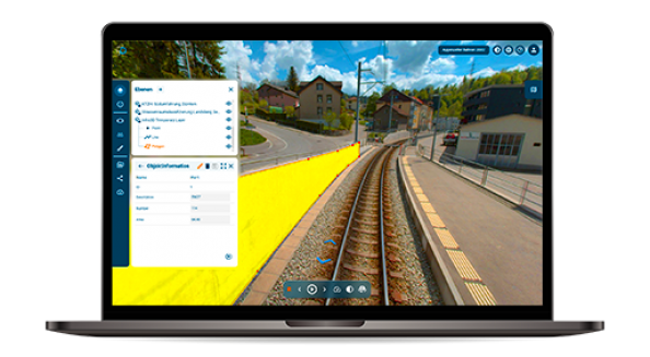
The SMARAIL Mobile Mapping System delivers high-precision image, laser and position data along railway and tram routes. The software solutions infra3D Edit and infra3D View make this data available as a digital infrastructure twin via a web-based platform, enabling efficient analysis, surveying, documentation and planning directly at the workplace.
AI-supported and manual analyses significantly expand the scope of data utilisation. These include, for example, the automated identification of track structure type sections, as well as clearance analyses and other specialist evaluations. In this way, 3D data is transformed into reliable information for maintenance, planning and operations – quickly, precisely and transparently.
Our ARGE FahrwegDiagnose consortium also expands the range of services to include further services for the practical evaluation and interpretation of the data.
Technical details
- Standard capture configuration allows 360° image coverage (front and panoramic) with the highest possible 3D point density
- Tunnel system with high grey-scale quality for detailed and more precise analyses in dark environments
- Total geometric resolution of the individual cameras: 121 megapixels (optional: 153 megapixels)
Features of the SMARAIL system
- Panoramic camera
- Colour front stereo camera
- Grey-scale front stereo camera
- Scanner (single-scanner technology)
- Two GPS/GNSS antennas
- Inertial measurement unit (IMU)
- Alignment with track survey points without the need for target plates
- Stroboscopic IR lighting
Options
- 45° colour monocular cameras (left/right)
- Track colour monocular camera 45° (front bottom)
- Butterfly configuration with 2 scanners


